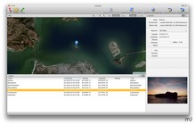
HoudahGeo is a one-stop photo geocoding solution for OS X. Export geotags to EXIF, XMP and IPTC. GPS device optional.
HoudahGeo "pins" photos to locations where they were taken. Professional grade processing. Mac ease of use.
HoudahGeo can store latitude, longitude, and altitude information right within the image file -- invisibly, with no loss of quality. HoudahGeo writes EXIF, XMP, and IPTC tags.
HoudahGeo projects may be published to EveryTrail or viewed and shared using Google Earth. Geotagged photos may be saved to Evernote or uploaded to


